

Fifty state outlines sounds like fifty things to memorise. It is closer to four. Almost every state belongs to one of four shape families, and once you can sort a silhouette into its family, you are choosing between a handful of candidates rather than the whole set.
This guide covers the families, the pairs that trip up nearly everyone, and a practice order built from the actual geometry — we measured all 1,225 state pairs to work out which states are genuinely isolated and which sit in a crowd.
What you’ll learn
- The four families that cover all 50 outlines
- Why the rectangles are the hardest group, not the easiest
- Eight confusable pairs, with one reliable tell each
- A practice order that front-loads the states you will actually meet
The Four Shape Families
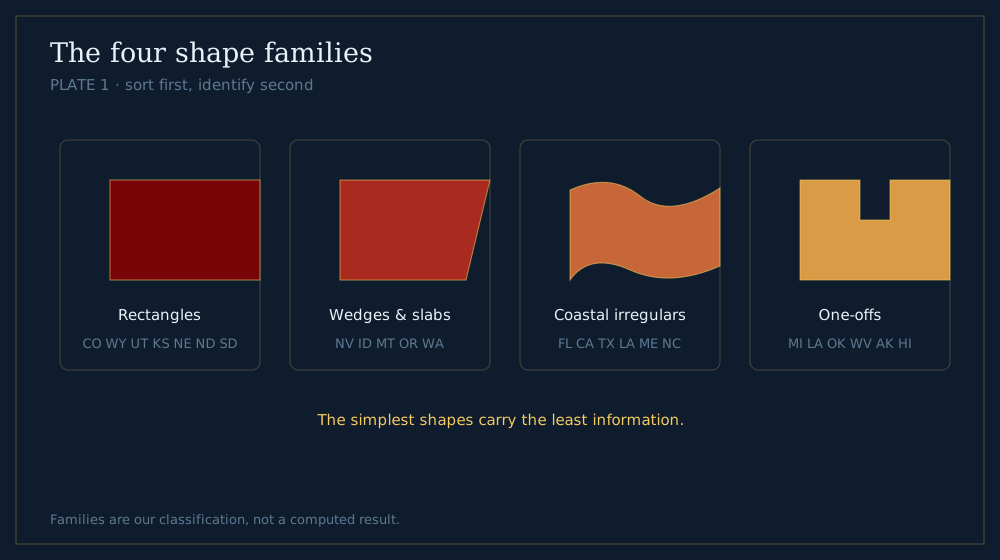
Plate 1 - sort first, identify second.
Sort first, identify second. The sorting takes under a second once you know what you are looking for.
Family 1: the rectangles
Colorado and Wyoming are pure rectangles. Utah, New Mexico, Kansas, Nebraska, North Dakota, South Dakota, Iowa and Oklahoma are rectangles with one or two bites taken out.
These are the survey states — drawn on a grid by people with rulers, not by rivers. They cluster in the Great Plains and the mountain west, which is itself a clue: a rectangle is almost never coastal.
Family 2: the wedges and slabs
Nevada’s slanted west edge. Idaho’s chimney. Montana’s long slab with a wavy top. Oregon and Washington’s blunt blocks.
The tell is that one edge follows something natural — a river or a mountain line — while the others are straight.
Family 3: the coastal irregulars
Anything with a real coastline: Florida, California, Texas, Louisiana, the Carolinas, Maine, New Jersey, the Gulf and Atlantic states.
These have the most character, and they are the easiest to learn, because coastlines are memorable in a way that survey lines are not.
Family 4: the one-offs
States whose shape is unique enough to be its own category. Michigan’s two peninsulas and mitten. Louisiana’s boot. Oklahoma’s panhandle. West Virginia’s ragged wedge. Alaska and Hawaii.
Learn these first. They are free points, and they clear roughly a fifth of the map before you have done any real work.
Why the rectangles are the hardest, not the easiest
This is the counter-intuitive part. A rectangle is easy to describe and almost impossible to identify in isolation.
Colorado and Wyoming are both rectangles. Without a scale reference or surrounding context, the only difference is the aspect ratio — and Wyoming is only slightly wider relative to its height.
The states that look simplest carry the least information. Budget your practice accordingly.
The Pairs Everyone Confuses
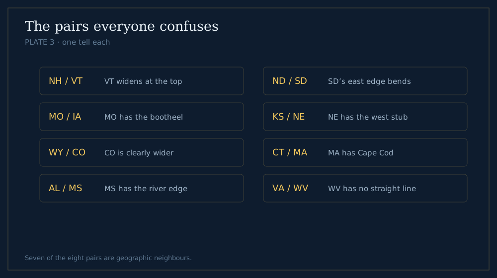
Plate 3 - seven of the eight pairs are geographic neighbours.
Eight pairs account for a large share of wrong answers. Each has one tell worth memorising.
New Hampshire and Vermont
Both are narrow northern wedges, and they sit side by side.
The tell: Vermont’s widest part is at the top; New Hampshire’s is at the bottom. Vermont is a wedge pointing down, New Hampshire a wedge pointing up.
Missouri and Iowa
Both are lumpy quadrilaterals in the middle of the country.
The tell: Missouri has a bootheel — a small notch dropping off its south-east corner. Iowa has two river edges and no notch.
Wyoming and Colorado
Both are rectangles.
The tell: Colorado is wider than it is tall by a clear margin; Wyoming is closer to square. If you have any neighbouring context, Colorado is the one with the mountains cutting through the middle.
Alabama and Mississippi
Both are tall rectangles with a small Gulf coast at the bottom.
The tell: Alabama’s south-eastern corner juts out toward Florida’s panhandle. Mississippi’s western edge is a wavy river line for its entire length.
North Dakota and South Dakota
Both are wide rectangles stacked on each other.
The tell: South Dakota’s eastern edge bends — the Missouri River cuts a diagonal through it. North Dakota is squarer and cleaner.
Kansas and Nebraska
Both are wide, both are flat-bottomed.
The tell: Nebraska has a distinct panhandle stub on its western end and a bite out of its north-east. Kansas is a clean rectangle with one small notch at the top-left.
Connecticut and Massachusetts
Both are small New England blocks.
The tell: Massachusetts has Cape Cod, a hook curling into the Atlantic. If there is a hook, it is Massachusetts.
Virginia and West Virginia
They interlock, so seeing one without the other is disorienting.
The tell: West Virginia is jagged on every edge with no straight lines at all. Virginia has a long straight southern border and a coastal east.
The pattern in these pairs
Seven of the eight pairs are geographic neighbours. That is not coincidence — states drawn in the same survey era, by the same conventions, ended up looking alike.
It also means context saves you. If a game gives you a direction clue, a confused pair usually resolves instantly.
The Isolation Ranking
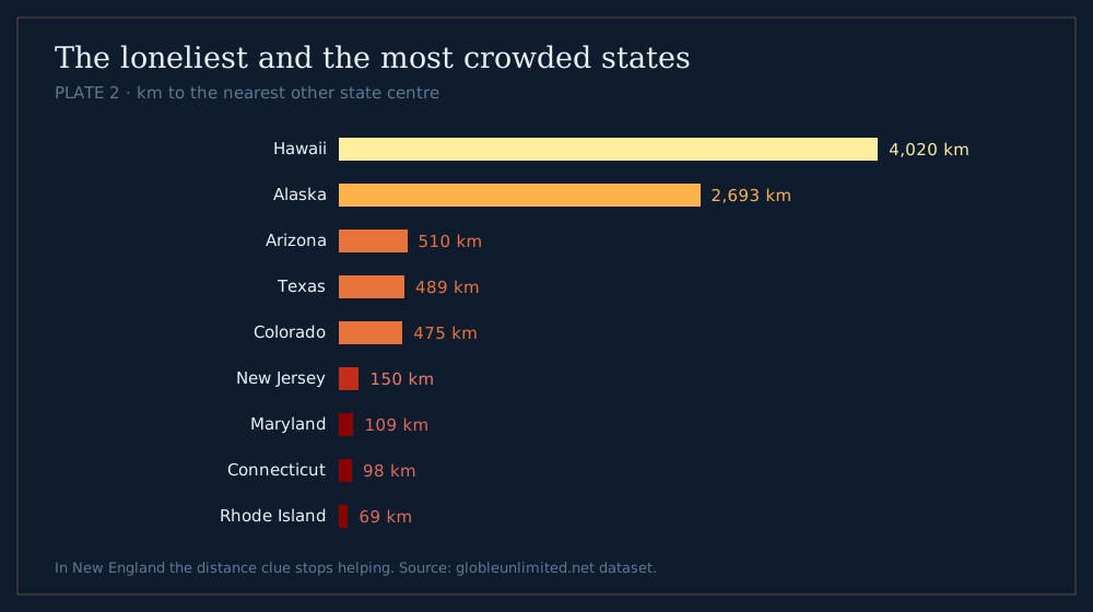
Plate 2 - in New England the distance clue stops helping.
Shape is half the problem. In a game that also reports distance, how isolated a state is decides how much that distance is worth.
We measured every state centre against every other one.
The loneliest states
| State | Distance to nearest other state centre |
|---|---|
| Hawaii | 4,020 km |
| Alaska | 2,693 km |
| Arizona | 510 km |
| New Mexico | 510 km |
| Texas | 489 km |
| Montana | 480 km |
| Idaho | 477 km |
| Colorado | 475 km |
Hawaii and Alaska are in a category of their own. After them the gap closes fast — the western interior states sit around 480–510 km from their nearest neighbour.
The tightest crowd
| State | Distance to nearest other state centre |
|---|---|
| Rhode Island | 69 km |
| Massachusetts | 69 km |
| Vermont | 97 km |
| New Hampshire | 97 km |
| Connecticut | 98 km |
| Maryland | 109 km |
| Delaware | 109 km |
| New Jersey | 150 km |
Rhode Island and Massachusetts are 69 km apart. Eight states in the north-east sit within 150 km of a neighbour, which is well inside the resolution of any distance readout.
What this means for guessing
In the west, a distance reading is a real constraint — 480 km of separation is legible.
In New England it is nearly useless. Once you know you are in the north-east, switch to shape and stop reading the number.
Panhandles and Other Landmarks
Some features appear on so few states that spotting one ends the search immediately. Learn these before you learn anything else.
The four panhandles
A panhandle is a narrow strip extending away from a state’s main body.
- Oklahoma — a long thin bar running due west, the most exaggerated of the four
- Texas — a broad squarish block on top, not a strip
- Florida — the western arm along the Gulf
- West Virginia — the northern spike reaching up between Ohio and Pennsylvania
Idaho’s northern strip is often counted as a fifth, though it reads more like a chimney than a handle.
Peninsulas and hooks
Michigan has two peninsulas and is the only state split into separate landmasses by water on the mainland.
Cape Cod hooks off Massachusetts. Delmarva hangs below Maryland and Delaware. Florida is one long peninsula and hard to mistake for anything.
River borders
A wavy edge means a river, and rivers are named.
The Mississippi does most of the work: it forms the entire western edge of Illinois, Kentucky, Tennessee and Mississippi, and the eastern edge of Iowa, Missouri and Arkansas.
Using a wavy edge as a compass
If a silhouette has one wavy side and three straight ones, you are almost certainly looking at a Mississippi or Missouri river state — which places you in the central belt before you have identified anything.
That is a whole family eliminated from a single edge.
What the Distance Clue Adds
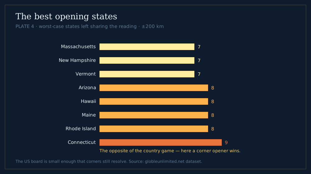
Plate 4 - the opposite of the country result.
Statele reports distance, direction and a proximity percentage alongside the outline. That extra information changes which opening guess is smart.
The best opening states, measured
We ran the same test we use for countries: for every possible opening state, what is the worst-case number of other states sharing the answer’s distance reading, within a 200 km tolerance?
| Rank | State | Worst case left |
|---|---|---|
| 1 | Massachusetts | 7 |
| 2 | New Hampshire | 7 |
| 3 | Vermont | 7 |
| 4 | Arizona | 8 |
| 5 | Hawaii | 8 |
| 6 | Maine | 8 |
| 7 | Rhode Island | 8 |
| 8 | Connecticut | 9 |
Why New England wins
This looks wrong at first. The north-east is the most crowded part of the map — how can its states be the best openers?
Because a corner is a good place to measure from, even when it is a bad place to be measured in. From Massachusetts, the rest of the country fans out across a wide range of distances, and few states share a reading.
The contrast with the country game
This is the opposite of the country result, where central openers such as Greece win and corner openers such as New Zealand fail badly.
The difference is scale. The United States is small enough that a corner opener still reaches everything with usable resolution; the globe is not. Advice does not transfer between the two boards.
The most central states
For reference, the states with the lowest mean distance to all others: Illinois (1,405 km), Indiana (1,425 km), Missouri (1,432 km), Iowa (1,446 km) and Kentucky (1,467 km).
Central is where you end up, not where you should start. An opener in Illinois reads mid-range against almost everything, which is the least useful answer a distance clue can give you.
A Three-Second Scanning Order
When an outline appears, run these four checks in order. Most states resolve on the first or second.
Check 1: is it a one-off?
Michigan, Louisiana, Oklahoma, West Virginia, Florida, Alaska, Hawaii, Texas, California. If it is one of these, you are done.
Check 2: does it have a coast?
A coastline immediately removes the entire interior — roughly half the map — and coastal shapes are the most distinctive.
Check 3: is it a rectangle?
If yes, you are in the survey belt. Now count the bites: pure rectangle means Colorado or Wyoming; one notch narrows it to Utah, Kansas or Nebraska.
Check 4: which way does it lean?
For the wedges, the lean is the identity. Nevada leans west, Idaho has its chimney north, Montana runs flat and long.
The check most people skip
Aspect ratio. Before anything else, ask whether the shape is wider than tall or taller than wide.
That one question splits the rectangles in half and costs you nothing.
Practice Order, Hardest Last
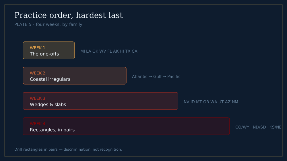
Plate 5 - rectangles last, and always in pairs.
Most people practise alphabetically, which is the worst possible order — it interleaves trivially easy states with genuinely hard ones and teaches you nothing about the families.
Week 1: the one-offs
The nine unique shapes. They build confidence and they are the states most likely to appear in casual quizzes.
Week 2: the coastal irregulars
Work down the Atlantic, then the Gulf, then the Pacific. Coastlines chain together — learning one teaches you its neighbours’ edges too.
Week 3: the wedges and slabs
Nevada, Idaho, Montana, Oregon, Washington, Utah, Arizona, New Mexico. Focus on which edge is natural and which is surveyed.
Week 4: the rectangles and the confusable pairs
Save these for last, and practise them in pairs rather than alone. Colorado against Wyoming, the Dakotas against each other, Kansas against Nebraska.
Why pairs, not singles
You will almost never need to identify a rectangle in isolation. You will need to discriminate between two of them, and that is a different skill.
Drilling them alone teaches recognition. Drilling them in pairs teaches the distinction, which is the part that fails under pressure.
What This Guide Can’t Tell You
Worth being straight about which parts of this are measured and which are judgement.
The shape families are our classification, not a computation. We grouped the outlines by eye after playing the mode. Someone else might reasonably draw the lines differently — five families, or three.
The confusable pairs come from experience, not error data. We do not collect what players guess, so the eight pairs are the ones that catch us and the ones that come up repeatedly in state-quiz discussion. They are not ranked by measured miss rate.
Only the distance figures are hard numbers. The isolation table, the opening-state ranking and the centrality figures are computed from all 1,225 state pairs. Everything about shape is qualitative.
That split matters if you are deciding what to trust. Take the tables as fact and the families as a useful lens.
Frequently Asked Questions
What is the easiest way to learn US state shapes?
Sort before you identify. Almost every state falls into one of four families — rectangles, wedges and slabs, coastal irregulars, and one-offs. Sorting a silhouette into its family narrows fifty candidates to a handful in about a second.
Which US states are hardest to tell apart by shape?
The rectangles, because they carry the least information. Colorado and Wyoming are the classic pair — both are pure rectangles, differing mainly in aspect ratio. New Hampshire and Vermont, the Dakotas, and Kansas and Nebraska are close behind.
How do you tell New Hampshire from Vermont?
Vermont is widest at the top and narrows downward; New Hampshire is widest at the bottom and narrows upward. They are mirror-ish wedges sitting side by side, which is why they are confused so often.
Which state is most isolated from the others?
Hawaii, whose nearest other state centre is 4,020 km away, followed by Alaska at 2,693 km. Among the contiguous states, Arizona and New Mexico tie at 510 km. At the other extreme, Rhode Island and Massachusetts are just 69 km apart.
How long does it take to learn all 50 state outlines?
Four weeks of short daily sessions is realistic if you practise by family rather than alphabetically — one-offs first, then coastal states, then wedges, then the rectangles in discriminating pairs.
Method. Distances are great-circle between state centre points, computed with the same haversine the game uses; all 1,225 state pairs were measured. Shape families and confusable pairs are our own classification, not a measured result — they come from playing the mode, not from an algorithm. Distance figures are reproducible from scripts/blog-data.mjs in our repository.
Try it: play Statele Unlimited, or read the country version of this field guide.